Saturday 29 October 2016

New Mexico Trip #37: Wheeler Peak Expedition, Part 3

HIKE #3--Wheeler Peak

I admit going to bed nervous the night before the big hike.  I knew this would be the biggest hike of my life, if not the longest.  Elevation gain is everything, and once above 10,000' the body works in mysterious ways.  It appeared as if the weather would cooperate at least, if not our bodies.  I was not interested in "almost" making it to the top.  This was my one chance to reach the highest point in NM.  I would not be willing to undertake the same strenuous training program again next year, and the expense of getting here.  It was now or never.

Last August we had hiked up to Williams Lake (see this blog for August 2015, or perhaps Sept. when I finally got it written up).  The trail to Wheeler shares the same path for about 1.8 miles and 1,000' of elevation gain.  After this junction, the real work begins, with a further 2,000' of elevation in just over 2 miles.  And little did we know just how rocky the trail was up there.  It's one thing to say that there is a trail to hike on, and another to actually find a trail to hike on.  Nearly a mile of the upper trail was nothing more than scrambling carefully across sloping rock slide aftermaths.  One false step and it was twisted ankle time, or even much worse.  Good luck getting back after that happens.

Hike #3:  Wheeler Peak, NM:   8.6 miles; 3035' (10,200'-13'161'); 7 hrs. 45 min.:
We left the trailhead parking lot above the Taos ski valley just before 10 am.  About 45 minutes of hiking later we turned off onto the Wheeler Peak Trail.  The early part of the hike is dense woodland, and this continues all the way to tree line.  After that it is an exposed hike, with so many switchbacks that I lost count.  We kept finding places where Deb could wait for me while I continued uphill, and she kept going a little further, a little further...

We took many short breaks, as the oxygen gradually disappeared around us.  After a grueling 4 1/2 hrs WE made the summit, nearly blown off by the ferocious afternoon wind.  Only one other person was there, and he took our photo!  We didn't stay long due to the wind and our very lengthy ascent.  I had no wish to be scrambling down across those rocks in twilight!  It took nearly three hours to get back to the car, and I was certain I had completely worn out my knees.

All of our planning and training had paid off.  However, little doubt remained in our minds as to who was master.  Wheeler had kicked our butts!  It's hard to describe the feeling one gets when the summit is reached, and there is no more need to go any further uphill.  Party time, but too tired to party.  With most of New Mexico spread out before us, it was quite a scenic buffet.  Without the camera and some very amazing photos, the trip up and back would have held much less meaning.  It's very hard to appreciate it all in such a short time when you are working so hard to get up there, arriving exhausted and deprived of oxygen.  Only afterwards, when I began studying the photos I took, was I able to fully realize my dream come true.  Vivid memories of being up there are fleeting, but the photos will last us a lifetime.  Hope you enjoy....
 
 Going up!  Scroll right.

 Dark woods kept things shady and cold.  It was in the 30s F when we left the car.  Up top it was in the low 40s.


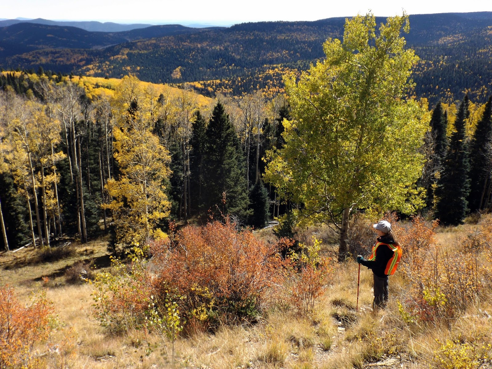
 Still early in the hike the trail passes many old rock slides.  Later, we would have to cross several of these, and they weren't fun (very photogenic, though).


 The fun and games end at the trail junction.
 

Once above tree line (near 12,000') the views begin to open in totally amazing ways!  This view is at about 11,400'.
 

Slowly but surely we gained elevation.  Williams Lake is now far below us.  About 11,800' and climbing.


Wheeler Peak is in sight, but still way too high above us.  A few hardy trees survive up here.


A slip and fall would likely land you in Williams Lake, barely visible at the bottom of the scary rock slide.  Lake Fork Peak is opposite, and yes, we would climb higher than it.


Deb is on final approach.  Neither of us had expected her to make it up top, but she sure as hell did!!!  The peak directly behind her is Mt. Walter, the 2nd highest peak in NM.  I popped up there on our way back, scoring two 13ers on this hike!


Wheeler Peak!!!  Holding on to each other so we don't blow off the summit!


Two other summits seen from Wheeler--Old Mike, a 13er, on the left, and Simpson Peak on the right, in the high 12s.  Had it not been so windy I would have attempted Simpson today.


Baldy Mtn, left, and Touch-Me-Not Mtn on right, both 12ers.


Detail from a photo taken up top showing our previous high point.  Several years ago we hiked Little Costilla Peak with Amanda, and here it is (left).  Ash Mtns. are the lower peaks to the right of it, with grassy Valle Vidal sprawling in the mid-background.


Summit panorama from Wheeler Peak--we shared the summit with one other guy (he took our photo!)  Scroll right to see everything!!


Another smaller panorama, looking north.   Scroll again!


 View from my secondary climb to Mt. Walter, looking east.  In the far distance are the Great Plains, 7,000' below.  In the far left background is the south end of Touch-Me-Not.


Old Mike is on the right, and Red Dome on the left.  Between and behind them is a vast open space which I have not been able to identify yet.


What goes up must come down.  Deb pokes along behind me.


Late afternoon sun shimmers across Williams Lake, as we return to tree line and slightly more oxygen.


We were back in Taos Plaza at sunset, and it was a beauty.  A perfect end to a dream come true!


As one adventure comes to an end, we are already in the planning stages of our next one, which will involve heading across the Atlantic Ocean once again.  We are momentarily done with the Southwest, having travelled there in March (El Paso and the desert), April (Denver), and now October.  However, I can't wait to return again someday soon, perhaps next autumn.  May all your adventures be at least as wonderful!  Thanks for stopping by.

Mapman Mike


Thursday 27 October 2016

New Mexico Trip #37: Wheeler Peak Expedition, Part 2

Hike #2

We scheduled a full day off between hikes, enabling a few scenic drives and visits to other towns.  With our first big hike behind us, we took a relaxing drive through the mountains, heading south from Sipapu to Mora and Las Vegas.  We have visited Mora once before, and wanted to do so again.  Largely it is a small Hispanic mountain town that time seems to have forgotten.  Our main interest in coming here was to revisit the Mora Valley Spinning Mill and Coffee Barn.  This is a beautiful shop, with locally produced and manufactured (by hand) woolen and alpaca goods.  Deb ended up buying a winter hat and gloves.  Mora is only about half an hour from Sipapu, following a highly scenic drive.  The town itself is surrounded by unique mountains.  Half an hour south of Mora is Las Vegas (NM), a much larger town with a train station and interstate access.  The town straddles the mountains to the west and the Great Plains to the east.  We visited the Old Plaza here once again (it had been many years), greeted the Southwest Chief at the Amtrak station, and had lunch at El Fidel, located near the station and within a working, historic hotel.

Our Sipapu room had a fireplace, and we were able to stock up on firewood in Mora.  It was an adventurous day spent in civilization, after being completely alone all day yesterday.
One does not need to hike to enjoy the autumn splendour of NM.  The drive to Mora from Sipapu crosses a high mountain pass before descending into the Mora Valley.  This photo looks back at the pass we crossed on our way south.


Hermit Peak looms over Las Vegas, NM.  There is exciting hiking to be done in this area, which remains unexplored by us.

Southwest Chief pulls into Las Vegas station, heading west.  We have passed through on the Chief twice westbound and twice eastbound, but this was our first "outside" station visit to Las Vegas.


 Early moonrise, as seen from our balcony at Sipapu (Apartment 9b).


 Friends came to visit us on our balcony, too.  Even more often when we began handing out peanuts.


HIKE #2:  South Boundary Trail:  7.9 miles; 7200'-9215'; 6 hours:  This hike was a bit longer than the first one, and involved more elevation gain.  However, last hike we had begun at 9200', and today we ended at that elevationThis hike begins only 2.8 miles west of the main Plaza in downtown Taos, so it is a busy one.  Bicycles were allowed, but not hunters.  We saw three bikes all day, and two of them passed us while we were at our off-trail day camp.  We did meet about 10 hikers, and ended up chatting and mostly walking back down afterwards with two young women.  We were in no rush to get started, enjoying a leisurely breakfast at our cabin, but were climbing by about 10 am.  Much of the time we were in the pinon-juniper belt, with the landscape dominated by these two types of trees.  The trail was very good, though rocky in places.  It was a steady uphill pull, with some sections becoming very steep.  At about the 8500' level, ponderosa pines took over the forest, along with other mixed conifers.  There were aspens near the summit.  This was not a mountain climb, though stupendous views opened up early on.  We hiked to the junction with a major trail at the 9200' level, found a place to relax, and enjoyed our time aloft.

 200' contour map of Hike #2.


 My source of drinking water today was the Rio Fernando.  A small
footbridge crosses the Rio from the parking lot, and the trail begins.


The trail follows the river a short distance before it begins to climb.  It felt like Lothlorien!


 Deb gets ahead of her photographer on the South Boundary
Trail.


River of Gold!!  Once we gained a bit of elevation, we could see the cottonwood 
trees along the Rio Fernando, and also Hwy 64.  Looking east.


Aspens in the high country!


Wheeler Peak from our day camp.  It is the peak on the far left, way back.  Our view today was  much closer than from Hike #1.  It was hard to believe we would be attempting to get up that mountain in only two days.  My knees felt all wobbly.


Deb at our Hike #2 high point and day camp.  Wheeler Peak in back left sits 4,000' higher.  It kept beckoning to us.


Looking northwest back towards Taos.  The thin, black, horizontal line in the mid-distance is the Rio Grande Gorge.


Interesting clouds above our trail.

After the hike we went back into Taos for coffee.  Then, after a stroll round the plaza, we went for dinner at Eske's Brewpub.  Their green chile beer and green chile enchiladas are pretty hard to beat.  And there is always lots of food left to take home.  Next day we came back to Taos, visiting a different brewpub.  We also made a major art purchase at our favourite gallery, a stone knife made in prehistoric fashion by one of the masters of the trade.  I will try and include a photo of it in the third and final blog entry...
 This place had over 20 taps--I managed to try three.  Hoping to return!!


 Pooh and I watch for honey bees in Taos Plaza.


Deb heads towards Taos Plaza.


Even the sewers are worth checking out in Taos!


Taos Mtn., seen from downtown Taos, NM.


The third and final entry in this series will describe our third and final hike, the "Bucket List Hike" to Wheeler Peak.  Hope you come back!
Mapman Mike

To be Cont'd... 


Wednesday 26 October 2016

New Mexico Trip #37: Wheeler Peak Expedition Part 1

My wish to climb Wheeler Peak did not come out of the blue.  Ever since I bought my first hiking guide to NM in the mid 1980s, I have wanted to climb that peak, the highest in NM.  Since then about 50 other mountains have been climbed in that state, including two beauties last March.  Most people picture NM and Arizona as desert, and nothing but.  However, there are many different life zones there, and we are often making comparisons between NM and northern Ontario, where I grew up.  Evergreen trees dominate the mountains in NM, though once above tree line (about 12,000') you are in the Arctic tundra, also called the Alpine Zone.  Very little grows up there except lichens and some hardy, short grasses.  Winds can be ferocious.

Back at home (the flatlands of Essex County, Ontario), training began 10 weeks before summit day.  Three weeks of gentle walking every day to tighten up the muscles a bit, and then 7 weeks of much more intense training.  Luckily we have access to a local area park with some significant hills.  Knowing that my goal would be the most difficult I had ever undertaken, I did not skimp on the program, but followed it religiously, and exceeded my own expectations on several days.  It was a slow, painful grind, but as our fitness levels increased we slowly grew more confident.  At present the plan was for Deb to go part way up the mountain, find a suitable area to make a day camp, and wait for me to summit and then return to her.  Since being on her RA meds she has had some problems with higher elevations, including dizziness and nausea.  We weren't going to take any chances.  She would also have the option of simply turning around and returning to the car and ski area.

Never having visited NM in the autumn, we planned one of our three hikes as a chance to view aspen leaves in their full golden glory.  The two hikes preceding Wheeler Peak would be among the toughest we had ever done--there was no easy warmup hike--in the hopes that we would be ready for the big one.  We flew to Denver via Southwest Airlines.  Not only was it very inexpensive, but we were allowed checked baggage with no additional fees.  The flight is ridiculously short--from the middle of the Great Lakes area to the edge of the Rocky Mtns. in about 2 1/2 hours.

We slept in Denver the first night (at 5,000'), driving next day to Sipapu in NM, where we spent five nights (at 8,100').  This would greatly aid us in getting used to the altitude.  Our arrival night in the NM mountains was very cold, rainy, foggy, and windy, with snow falling in the much higher elevations.  We were chilled to the bone when we finally got all our gear into the upstairs, unheated cabin.  However, for the remainder of our stay in NM the weather was exactly as I had always dreamed it would be here in autumn.  Our days were sunny and cool, though there was some wind on a few of them.  It turned into an outstanding week for hiking, and we could not have been happier.
View from our balcony at Sipapu.
 

HIKE #1:  The KNOB

We had unfinished business with The Knob, a summit in the Santa Fe Mountains, part of the Rockies.  Last August (2015), after a grueling climb, we had nearly made it to the summit when we were chased down by lightning and rain.  So near and yet so far.  This year we started out from a different starting point, so except for the final 15%, this hike was completely different than the first one. 

Hike #1--The Knob  Darkest contour lines are every 200'.

Hike #1--The Knob:  7.25 miles; 9,000'-10,625':  We were out for 5.5 hours on this incredibly beautiful hike, one that we would both do again if given a chance, especially in the fall.  We had  time at the summit today, there being no storms visible anywhere.  There are many places on the way up to pitch a tent for a few days and explore, and there are several connections with other trails, too.  Let's get to the photos!
Trail 19A was ours!

 Crossing Rito Angostura, our version of the Withywindle.
It was possible we would encounter hunters today, thus 
the orange vests.  We saw no one.  All day.

 Early on during Hike #1.  We were already at one with the universe!

To begin, we had to hike a dirt road that passed by some incredible summer homes/cottages.  The road soon ended and we were on a trail.  After about half a mile we came to a junction and turned north onto our trail.  Everything in NM goes either steeply up or steeply down.  There is seldom any in between.  Today's climb was gentle, though, at least part of the way.  We were soon completely alone in the world.  With frequent short stops to allow our lungs and hearts to catch a break, we made steady progress through a beautiful woodland of pine and aspen.
 We were occasionally dazzled by colour on this hike.  It was very cool, and much of our walk was in shade, due to the low angle of the sun.

The higher we climbed, the more beautiful it became.  The only wildlife we saw today were squirrels, birds, and a tiny snake out sunning himself on the trail.

 About halfway up we came to this beautiful high meadow, with a small stream passing through it.  Our trail lies ahead.  ATVs and bicycles are allowed here, but we saw no one all day.

 Another clearing with aspens in full colour.  A mighty fine day!

Midway through the hike we came out onto a bright, large and very beautiful meadow (seen on map, above, and photo).  This would be an ideal place to set up a tent for a few nights.  No water would have to be carried, as there is a small mountain stream passing through.  Speaking of water, at the beginning of each hike I filled my filter bottle with water from the local stream.  Today I was drinking water from Rito Angostura as I climbed.   Deb carries a bladder in her backpack, filling it with bottled water before hikes.  She can sip directly without having to stop and fish out a water bottle, as I do. 
We rested in the shade at the top of the meadow (north end).  Afterwards, the climb became more severe.  We would climb through a magical wood, then emerge into a small clearing.  This sequence occurred five more times before we finally arrived at the high saddle, where our trail from last summer came up to meet us from the other side of the mountain.  The side trail to The Knob heads east from up here.  We didn't have to climb very long to reach a wonderful log with views out across the mountains.  We were well over 10,000', and feeling very fine.  There is a natural high one gets when hiking in high altitudes.  Humidity was non-existent, another factor that helps the hiker feel amazing.  We sat and ate our lunch, gazing at some of the world's best scenery.
 Lunch with a view, stopping just before final approach to The Knob.  Bare summit in the distance is over 12,000'.

 Telephoto shot showing a detail from previous photo.  Some aspens are peaking, others have lost their leaves, and some (foreground) are still mainly green!

Final very steep climb up The Knob itself.  This final 180' of elevation gain took some time, but views were tremendous so we didn't mind stopping to gulp some oxygen.

View north from a very windy Knob!  In the far background is Wheeler Peak.  The canyon that comes up the center of the photo describes our hike from last summer.

 Wow!  From The Knob.

The Knob is just that--a giant knob on top of a mountain, rising about 200' like some unimaginatively large earthwork tomb.  The east slope is bare, and that is where we climbed it.  However, it is so steep that any misstep would cause the climber to roll down all the way to the bottom.  No cactus, anyway.  So we took our time, eventually making the summit.  The top had a trail going all the way round, with many shorter trees up there along with areas of bare rock affording views to the infinite.  We set up a day camp in a sheltered area, and began the first of two encirclings.  It was extremely windy on the north end, but our new jackets proved equal to the elements.  We found a small jar with a pencil and notebook, adding our names to the short list.  Someone else had been here Oct. 1st.  Today was Oct. 10th.
Our day camp area atop The Knob 

 Jicarita Peak from The Knob.  That mountain is one of the highest in the state, at over 12,800'.  A few years ago we camped beneath it and had plans to climb it.  However, I had brought the wrong lid for the water filter bottle.  We had to come back early because we did not have enough drinkable water to remain and climb to the summit.  I will never live that one down.

It was so windy up on The Knob that I don't know how my hat stayed on.

We enjoyed our time at the top immensely.  However, we had burned through most of our food on the uphill portion of our hike, and still had many miles to go to get back to the car.  Cold, fresh air gives one an appetite, I can tell you.  With only a Clif bar to share for the 2nd part of the hike, we reluctantly headed back down mid-afternoon.  It is hard to judge how much food to bring on a hike.  Sometimes you are simply not hungry.  At other times you could eat a whole tree.  No one wants to carry anything up a mountain that isn't necessary, so packing is usually quite economical.  With a few more Clif bars, however, The Knob would have been our home until much closer to sunset.
Mapman Mike
End of Part 1...to be continued